
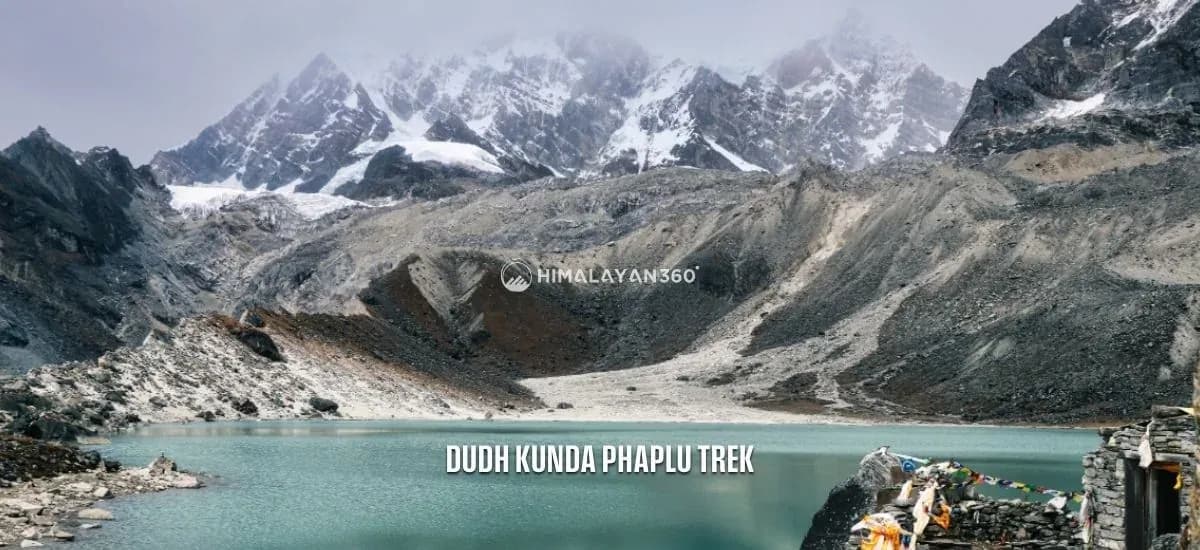
Dudh Kunda is a sacred glacial lake in Solukhumbu district, eastern Nepal, sitting at the foot of Numbur in the lower Everest region. The most common answer to how high it is, 4,560m, is repeated across almost every trekking listing on the internet. It is also, on the evidence below, probably a little low.
Here is the short version. Published figures for the lake run from 4,560m to 4,610m. Two independent satellite elevation models put the lake basin at 4,615m and 4,622m. Nobody has published a surveyed figure. Plan for roughly 4,600m and you will not be wrong in any way that matters.
The lake sits at roughly 27.71N 86.60E, about 22KM north of Phaplu airport, 13KM west of Lukla and 44KM southwest of Everest. This page covers the altitude question properly, the exact location, the route in from Phaplu and the day by day profile.
Dudh Kunda at a Glance
| Altitude | About 4,560m to 4,620m. Sources disagree; see the section below |
| Coordinates | Roughly 27.71N 86.60E |
| Where | Ward 1, Solududhkunda Municipality, Solukhumbu district, Koshi Province |
| Type | Glacial lake, mapped at roughly 540m north to south by 330m east to west |
| Name | Dudh (milk) and kunda (sacred pool), so Milky Lake |
| Local name | Shorong Yul Lha, the protector of Solu |
| Peak above it | Numbur, 6,958m, summit 5.4KM away |
| Nearest airport | Phaplu, 2,413m, about 22KM south |
| From Kathmandu | About 122KM in a straight line |
| Trek length | 7 days and 46KM on the Himalayan 360 itinerary |
| Pilgrimage | Janai Purnima, the full moon of Shrawan, in August |
How High Is Dudh Kunda? The Sources Do Not Agree
This is the single most searched fact about the lake, and it deserves a straight answer rather than a confident one.
No surveyed elevation for Dudh Kunda appears to have been published. What exists is a set of figures repeated between trekking companies, plus what satellite terrain data shows. They do not match.
What the published figures say
| Figure | Where it appears |
|---|---|
| 4,560m | The dominant figure across trekking listings. It is also the figure in Himalayan 360's own day 4 itinerary and in this site's Everest region altitude table |
| 4,561m | The "Max. Altitude" fact on the Himalayan 360 trip page, one metre off its own itinerary |
| 4,592m | Quoted on several Pikey and Dudhkunda cultural trail itineraries |
| 4,600m | Adventure Alternative, which states plainly that "Dudhkunda Lake or Milky Lake at 4600 metres is a sacred place at the base of Nombur Himal" |
| 4,610m | Also in circulation, usually alongside a 15,125 feet conversion |
| 4,300m | An outlier that appears on one of this site's own older pages. Treat it as wrong |
That is a spread of about 50m between the serious figures, which is small in absolute terms and large as an indication that nobody is measuring anything. The 4,560m number is almost certainly repeated rather than sourced.
What the terrain data says
Dudh Kunda is mapped in OpenStreetMap as a named water body, which gives an outline rather than a single point. Sampling 46 points spread across the inside of that outline against two independent global elevation models produces this:
| Dataset | Median | Range across the lake |
|---|---|---|
| SRTM, 30m grid | 4,622m | 4,599m to 4,641m |
| ASTER, 30m grid | 4,615m | 4,598m to 4,632m |
Two datasets built from different instruments land within 7m of one another, and both sit above every published figure.
The caveats are real and worth stating. These are 30m grids, so a lake this size is covered by only a few dozen cells and the edge cells inevitably catch shoreline and slope rather than water. Global elevation models carry a vertical error budget of roughly plus or minus 10 to 20m, and that error grows in steep terrain, which is exactly what surrounds this lake. Radar and stereo-optical sensors also behave awkwardly over water and snow. And "the height of a lake" is itself ambiguous, because the water surface, the shoreline and the lip of the basin are not the same altitude.
So what number should you use?
Somewhere around 4,600m. If you want a single figure to plan against, use that. If you want to be precise about your uncertainty, say 4,560m to 4,620m and note that the low end comes from repeated listings and the high end from satellite terrain models.
What does not change across that whole range is the practical consequence. Every one of these numbers puts Dudh Kunda more than 4,500m above sea level, in the band where acute mountain sickness is common and where the ascent rate matters more than the exact altitude. A guide who tells you 4,560m and a guide who tells you 4,620m should be giving you identical advice.
Where Dudh Kunda Actually Is
The lake sits at roughly 27.71N 86.60E, in ward 1 of Solududhkunda Municipality, Solukhumbu district, Koshi Province, in eastern Nepal.
That municipality name is the most useful location fact on this page. Solududhkunda is a compound of the Solu river and Dudhkunda, the lake east of it. When Nepal restructured its local government the area took its name from this lake. The municipality was established on 3 December 2014, covers 565.06 square kilometres, had a population of 24,323 at the 2011 census, runs to 11 wards, and is administered from Salleri, the district headquarters, in ward 5. Salleri is a place you walk through on day one of the trek.
This is Solu, the lower and greener half of Solukhumbu, not Khumbu, the high Sherpa country above Namche. The distinction explains a lot about the trek: forest instead of moraine, farmland instead of glacier, and almost no other trekkers.
Distances from the lake, calculated as great circle lines between published coordinates:
| To | Straight line distance | Note |
|---|---|---|
| Numbur summit | 5.4KM | The 6,958m peak the lake sits beneath |
| Karyolung summit | 2.7KM | The closest of the big peaks, at 6,511m |
| Khatang summit | 5.1KM | Completes the wall around the basin |
| Ringmu village | 13.5KM | 2,785m, on the way back down |
| Taksindu | 13.3KM | 2,925m, the monastery stop on day 2 |
| Lukla | 13.1KM | Close, but there is a mountain wall between them |
| Nunthala | 14.5KM | 2,220m, on the main Jiri to Everest trail |
| Junbesi | 15.3KM | The classic Solu village and monastery town |
| Phaplu airport | 21.6KM | 2,413m, the trailhead you fly into |
| Pikey Peak | 23.5KM | 4,065m, often combined with Dudh Kunda on longer trips |
| Everest | 44.4KM | Northeast. Wikipedia independently places Numbur 43KM southwest of Everest |
| Kathmandu | 122.1KM | Due west. The road journey is more than twice that |
These are aerial distances, not walking distances. In this terrain the trail is routinely two to three times the straight line, which is why 13.5KM from the lake to Ringmu is a full day on foot.
The Mountains That Ring the Lake
Dudh Kunda sits in a basin closed on three sides by the Rolwaling Himal. All three summits are within about 5KM of the water.
- Numbur, 6,958m. Wikipedia gives the elevation as 6,958m (22,828 ft) at 27°45′16″N 86°34′23″E and places it 43KM southwest of Everest. This is the mountain the lake belongs to, and the one that Sherpa tradition calls Shorong Yul Lha, the god or protector of Solu. Trekking pages commonly round it to 6,959m.
- Karyolung, 6,511m. At 27°44′00″N 86°36′43″E, this is the closest big summit to the lake at 2.7KM. Wikipedia records it as first climbed in October 1982 by a party of two Japanese and two Nepalese climbers, and gives Khatang as its parent peak.
- Khatang. Sources disagree substantially on this one. Trekking and mapping references give 6,853m, while a published Nepal government list of peaks opened for mountaineering gives 6,582m. That is a difference of 271m, far too large to split, so both figures are given here and neither is endorsed.
Trekkers coming up from Taksindu are also told they will see Mount Everest on this route. That is credible, since Pikey Peak at 4,065m along the same ridge system is famous for exactly that view, but the sightline from any given point on the Dudh Kunda trail depends entirely on the weather and where you happen to be standing.
The Route: Phaplu to Dudh Kunda
There is no road to Dudh Kunda and no airstrip near it. Every route is a walk in from the south, and the standard one runs up the Solu side from Phaplu.
The shape of it, in one line: Phaplu, Salleri, Taksindu, Beni, Dudh Kunda, Ringmu, Phaplu. You climb roughly 2,200m from the trailhead to the lake, then come back down a slightly different way.
Village altitudes along the route, from OpenStreetMap elevation tags where they exist:
| Place | Altitude | Role on the route |
|---|---|---|
| Phaplu | 2,413m | Airstrip and trailhead |
| Salleri | About 2,390m per the trip itinerary | District headquarters, first night |
| Ringmu | 2,785m | On the descent. The trip page notes it for yak cheese and apple wine |
| Taksindu | 2,925m | Monastery and pass, second night |
| Beni | Day high point given as 3,972m | Last settlement before the lake |
| Dudh Kunda | About 4,600m | The lake |
There is a second, longer way in. The Pikey and Dudhkunda cultural trail approaches from further west, through Junbesi and Thuptenchholing, over the Choim pass to Beni, and reaches the lake from that side. It adds Pikey Peak, a 4,065m viewpoint that Adventure Alternative describes as a favourite of Edmund Hillary, and turns the trip into a 14 to 18 day journey rather than a week. If you have the time it is the better trek. If you have a week, the Phaplu approach is the one that works.
The Seven Day Itinerary and Its Altitude Profile
The day by day altitudes below come from Himalayan 360's own Dudh Kunda Phaplu Trek itinerary, which is the version of this route the company runs.
| Day | Stage | Day high point | On foot |
|---|---|---|---|
| 1 | Fly Kathmandu to Phaplu, trek to Salleri | 2,390m | 6 to 7 hrs |
| 2 | Salleri to Taksindu | Taksindu sits at 2,925m | 6 to 7 hrs |
| 3 | Taksindu to Beni | 3,972m | 5 to 6 hrs |
| 4 | Beni to Dudh Kunda | 4,560m | 5 to 6 hrs |
| 5 | Dudh Kunda to Ringmu | 4,560m | 5 to 6 hrs |
| 6 | Ringmu to Phaplu | 2,413m | 5 to 6 hrs |
| 7 | Phaplu to Kathmandu | 1,400m | Travel day |
Total trek distance on this itinerary is given as 46KM, spread over five and a half walking days, in tea house and lodge accommodation throughout.
Two things about that table are worth reading closely.
There is no acclimatisation day. You go from 2,413m at Phaplu on the morning of day 1 to around 4,600m on the afternoon of day 4. That is roughly 2,200m of gain in four walking days, most of it above 3,000m, where the usual guidance is to limit the gain in sleeping altitude to 300 to 500m per night. This itinerary does not do that. It is walkable, plenty of people complete it, and it is still the part of the plan most worth a conversation with your operator.
Day 7 is described inconsistently. The trip page's inclusions list return flights between Kathmandu and Phaplu, while the day 7 text describes a 7 to 8 hour drive. Both are genuinely possible from Phaplu. Confirm which one your booking covers rather than assuming.
Getting to Phaplu: Fly or Drive
Phaplu is about 122KM from Kathmandu in a straight line, and it is the rare Everest region trailhead you can reach either way.
By air
Phaplu Airport, code PPL, sits at 2,413m (7,918 ft) at 27°31′05″N 86°35′04″E, with a 680m asphalt runway. Nepal Airlines, Sita Air, Summit Air and Tara Air all serve it from Kathmandu. Operator listings put the flight at roughly 25 to 35 minutes.
A small note on the altitude, since it is the kind of thing that gets copied wrong: Wikipedia and Nepal's civil aviation authority give 7,918 ft, while Summit Air's own destination page says 8,035 ft. The lower figure matches the OpenStreetMap elevation tag for Phaplu village and the figure on Himalayan 360's own day 6, so 2,413m is the one used throughout this page.
Phaplu is the calmer alternative to Lukla. Tenzing Hillary Airport at Lukla sits at 2,846m with a 527m runway, so Phaplu is 433m lower with a runway 153m longer, and it is not subject to the notorious weather backlogs that strand people in Lukla for days.
By road
Unlike Lukla, Phaplu and Salleri are on the road network. Operators quote roughly 270 to 275KM and 9 to 11 hours by jeep or bus from Kathmandu to Salleri, with buses at the slower end of that. Those figures come from trekking companies rather than a highway authority, and hill road journey times in Nepal move with the season, so treat them as a band.
Driving in has one real advantage beyond cost. It gives you a day of gradual altitude gain before you start walking, which the flight does not.
Altitude on This Trek Deserves Respect
Dudh Kunda gets sold as an easy, cultural, lower Everest alternative. The culture part is true. The easy part needs qualifying.
At roughly 4,600m the lake is higher than Gosaikunda at 4,380m and higher than Annapurna Base Camp at 4,130m. It is not far off Everest Base Camp at 5,364m. The forest and farmland on the way up disguise this, because the terrain never looks alpine until suddenly it is.
The specific risk here is the ascent rate rather than the ceiling. Four walking days from 2,413m to 4,600m is quicker than most Everest region itineraries allow, and there is no rest day built in. Practical responses:
- Add a day if your schedule allows it, ideally at Beni or on the approach above Taksindu, and use it to walk high and sleep low.
- Know the symptoms. Headache, nausea, dizziness and disturbed sleep above 3,500m are the ones to act on, and descending even a few hundred metres usually settles them.
- Do not plan a summit push mentality around the lake. Reaching the water and coming back down the same day is a long day at altitude.
- Carry proper insurance. This is remote country with no road, and helicopter evacuation is the only fast way out.
If you want more detail on the mechanics, the site has a separate guide on altitude sickness prevention that applies directly to this ascent profile.
Why the Lake Matters: Shorong Yul Lha and Janai Purnima
Dudh Kunda is not a scenic lake that happens to be sacred. It is a sacred lake that happens to be scenic, and the difference shapes what you see when you get there.
The name means Milky Lake, from the glacial silt suspended in the water that gives it a pale, opaque colour. Numbur above it is Shorong Yul Lha in Sherpa, the protector of Solu, and the lake is understood as belonging to the mountain rather than the other way round. It is revered by Hindu, Buddhist and Kirat communities alike, which is unusual even in Nepal, and pilgrims bathe in it in the belief that the water washes away sin.
The main gathering is at Janai Purnima, the full moon of the Nepali month of Shrawan, which falls in August. This is the same day as Raksha Bandhan, and the same festival that draws crowds to Gosaikunda in Langtang. Thousands of people walk up to Dudh Kunda for it, from Nepal and from India, and a fair forms at the lake.
Going at Janai Purnima is a completely different trip from going in October. You will see the place as a living pilgrimage site rather than a quiet alpine basin, and you will share the trail. It also falls in the monsoon, so you should expect cloud, leeches lower down and a real chance of not seeing Numbur at all. Choose deliberately.
Best Time to Go
Himalayan 360 gives the season for this trek as February to mid-April and September to late November. That is slightly wider at the front end than the standard Nepal trekking seasons, and it fits a route that spends most of its time between 2,400m and 4,000m.
- Autumn, September to late November. The clearest air and the most reliable mountain views. Post-monsoon skies and the best chance of seeing Numbur, Karyolung and the Everest group from the ridges.
- Spring, February to mid-April. Rhododendron in the Solu forests, which is one of the genuine highlights of this particular trail, and quieter than autumn. Colder and possibly snowy at the lake in February.
- Monsoon, June to August. Cloud, leeches and slippery trails. The exception is Janai Purnima, when the pilgrimage is the reason to be there.
- Winter, December and January. Cold at 4,600m and snow likely at the lake. The lower half of the route stays walkable.
Permits and Cost
Himalayan 360 prices the seven day trip from USD 750, which covers the Kathmandu to Phaplu flights, lodge accommodation, all meals on the trek, a licensed guide, porters at one per two trekkers and permits.
On permits specifically, published sources contradict each other and this page will not pretend otherwise. Different operators list a Sagarmatha National Park permit, a TIMS card, a local Solududhkunda Municipality fee, and a Dudh Kunda area permit, in varying combinations and at varying prices. The Himalayan 360 trip page lists a National Park permit and a Khumbu Pasang Lhamu Rural Municipality entrance fee, which is the fee normally associated with the Khumbu rather than Solu.
For context on why this is muddled: Sagarmatha National Park was established on 19 July 1976, covers 1,148 square kilometres, and Wikipedia describes it as ranging from 2,845m to 8,848m with its southern extent at the Dudh Koshi and its nearest towns at Namche and Khumjung. Dudh Kunda lies well to the west and south of that, in Solududhkunda Municipality. Whether the park permit is actually required for this trail is not something the published sources settle.
The practical answer is to let it be somebody else's problem. Booking the Dudh Kunda Phaplu Trek as a package includes the permits in the price, so the operator resolves which ones apply. If you are walking it independently, ask at the Nepal Tourism Board office in Kathmandu before you fly, and expect the answer to differ from what you read online.
How the Numbers on This Page Were Checked
Coordinates and peak elevations for Numbur, Karyolung, Phaplu Airport and Tenzing Hillary Airport are from Wikipedia. Municipality figures, including the 2011 census population and the origin of the Solududhkunda name, are from Wikipedia's article on the municipality, as are the Sagarmatha National Park boundary details. The lake outline and the village elevation tags for Phaplu, Taksindu, Ringmu and Nunthala are from OpenStreetMap. Lake elevations were sampled from the SRTM 30m and ASTER 30m global datasets through the Open Topo Data service, at 46 points inside the mapped lake outline. Distances were calculated as great circle lines between those published coordinates, which is why they are given as straight lines rather than walking distances. Itinerary, trek distance, price and season come from the Himalayan 360 trip page. Where a figure could not be pinned to a source, it is flagged as disputed above rather than stated as fact.
 Trek
Trek By air
 Pilgrimage
 Festivals
 Wildlife
 Luxury
 Yoga
Yoga Food
Food Heritage